


Illimani, Ascendant: A Photographer’s Journey to the Highest Peaks in Bolivia

This summer, photographer and Feathered Friends ambassador Christian Murillo traveled to Bolivia to attempt several of its tallest mountains and photograph its glaciated peaks. This trip report tells the story of his adventures there. Words and images by Christian Murillo.
As our plane touched down at Bolivia’s El Alto International Airport, I felt my skin tingle. At the time, I wasn’t sure if this was caused by altitude or the strikingly beautiful views of the Cordillera Real mountain range.
After spending a couple weeks in La Paz and taking some short backpacking trips in the mountains, my lungs began to acclimate. Finally, it was time to take on Huayna Potosi, one of the most iconic and popular peaks in Bolivia’s Cordillera Real. Huayna Potosi is nearly 20,000 feet tall and has relatively easy access from the city. Although it is not the most technical peak in the range, the altitude is no joke, and the danger of taking on a mountain of this nature is always in the back of your mind. The week I got to Bolivia, a 45-year old German died on the exposed ridge just below the summit after losing his balance and falling 3,000 feet. Hearing this news just before setting out on the climb was a huge reality check and a stark reminder that the mountain is always in control.
The day of our summit push finally arrived. Starting our climb at 1 a.m., we ascended the glacier on the western face in the pitch black of night. The experience was almost numbing—we plodded endlessly in single file, as part of a long line of climbers making their way up the mountain. However, as the light of day began to show, it became evident that the line of climbers had thinned. The altitude was beginning to take a toll on many people, but a small group of us pushed on. Eventually, we made it up to an exposed ridge just below the summit. One side of the boot-width ridge drops 1,200 feet, and the other side drops almost 4,000 feet. For a brief moment, thoughts of the German climber flashed in my mind. If I let my mind wander to anything besides my next step, I could easily share the same fate as the unfortunate alpinist. With laser focus throughout the rest of the traverse, I made it to the summit just as the sun was rising, revealing incredible vistas over the Cordillera Real. I made it back down the mountain filled with limitless levels of stoke and I knew I could not wait much longer before getting another climb under my belt.
Only a week later, my cousin Ethan joined for our next climb, Pequeno Alpamayo (17,749’). Although Pequeno Alpamayo isn’t as tall as Huayna Potosi, it is more technical, with a beautiful 50 degree ascent up the exposed southern ridge. Despite cramps in my calves, we managed to fight our way to the top. As we stood on the summit, the rising sun illuminated a sea of clouds below us. The beauty of our view was unlike anything I had seen before and I sensed that I was becoming addicted to photographing these untouched alpine landscapes.

At this point, morale was high. We were two for two, and although we had not taken on the most challenging peaks in the range, we felt like we could push ourselves even harder. We decided to go for Sajama, Bolivia’s tallest mountain at 21,463 feet.
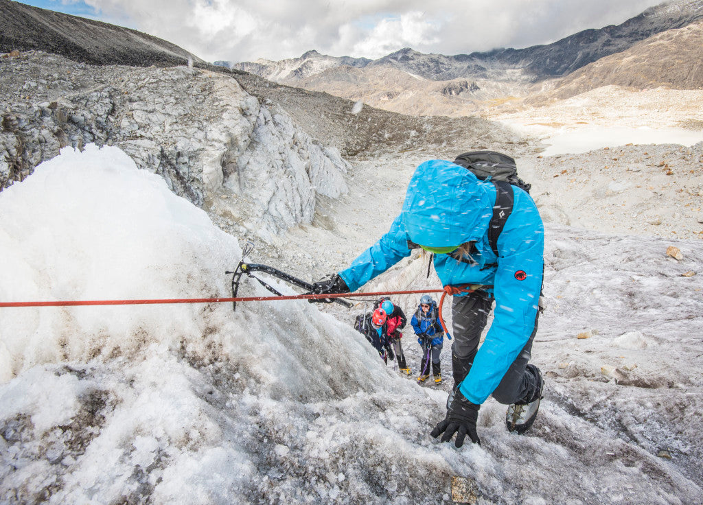
Nothing on Sajama went according to plan. Once we got there, we found out that we would be short a couple of porters, which meant that I had to carry a 45 lb. pack up almost 4,000 feet to get to high camp. This climb was easily the most exhausting in my life, as the scree and soft snow created a very unstable surface.
Just 50 feet below high camp, we caught our first glimpse of our tents. The violent wind had battered one of them, and it was obvious that it was severely damaged. The guide gave us a look that told us we needed to hurry to salvage what we could of the tent. After one final push, I made it to high camp, feeling weaker that I ever had in my life. I collapsed and lay on a sheet of ice for ten minutes before Ethan woke me up. My lips were beginning to turn blue, a symptom of acute pulmonary edema, caused by both the strain of the climb and the altitude.
As we lay in our tent that night, we all developed pounding headaches. The howling wind seemed as if it was piercing through our tent and going straight into our skulls. Nobody slept. At 11:00 p.m., when we were supposed to begin getting ready for the climb, our guide shouted, “Too windy, too dangerous, no summit today.” We waited to see if the wind would die down, but our journey on Sajama was nearing a premature ending.

In the couple days of rest after Sajama, the muscles in my legs felt like they might never feel normal, and my knee injury, which happened a week before heading to Bolivia, began to flare up again. However, as the days moved on, our fitness and morale improved as we searched for the next mountain. Illimani, the tallest mountain in the Cordillera Real, had always been on our radar, but it still seemed that we were not prepared after our recent struggles. We needed a confidence booster, something more attainable.
Ethan decided to head back to Huayna Potosi, while I had my sights on Mururata, a 19,262 foot mountain with a beautiful southern face. From La Paz, the mountain looks very underwhelming, earning the nickname the “beheaded peak”. However, from the south the summit stands on a 3,000 foot cliff overlooking a beautiful glacial lagoon. Approaching from the south meant that there were two possible routes. The first was an extremely dangerous direct mixed climbing approach up the cliff face. The second was a new route, which ascends a steep moraine, then meets the glacier halfway up Mururata. Although this involved a great amount of uncertainty, we simply did not have the technical experience to safely attempt the direct route up the cliff face.
After we arrived at base camp, our guide went to scout the route. We quickly realized that a series of 100 foot high bluffs were completely covered in ice. What was supposed to be a tricky yet non-technical rock scramble had turned into a dangerous sheet of ice. With only glacial travel gear on us, the route became impossible before we even started. Again, we had failed to reach our objective and the climb that was supposed to be a confidence booster for Illimani had left us feeling unprepared and lacking judgment. Now we were in a peculiar situation. Even with questionable weather in the forecast, we decided to have one last go in Bolivia. The decision came down to just one thing: we wanted to depart Bolivia having left everything on the table.

Just three days after returning from Mururata we set out for Illimani, a bumpy four hour drive from La Paz. We found ourselves in the town of Pinaya at the base of Illimani by 2 p.m., and immediately packed up our bags and made our way to base camp.
The trek up to Nido de los Condores (high camp, or “Condors Nest”) was a serious climb. With over 3,000 feet of elevation gain, this part of the climb was a struggle in itself. The views from high camp were spectacular—you could see the details in the glaciers and ridgelines. There were enormous seracs hovering over the glacier, and I got the feeling that anything could happen. It was very unsettling. To make us even more nervous, in the five hours that we lay in the tent, we heard over a dozen avalanches. We did our best to not think about it too much, but at this altitude, I found sleep nearly impossible. The sound of my heartbeat masked even the loudest avalanches.
At 1:40 a.m., we got a bit of food in our systems and geared up in the freezing cold. Feeling energized and ambitious, we set off up the western face of the mountain. A full moon stood high in the sky, faintly revealing hundreds of crevasses in the surrounding glaciers. Finally, we made it to 20,000 feet, a benchmark I had been itching to get to the entire trip. The air felt exceptionally thin, slowing down our progress and forcing us to take a big breath with every step. Although we were just over 1,100 feet from the summit, the hardest climbing remained ahead of us, including a 1,000-foot push up a 55-degree slope. We climbed on all fours, one hand pressing the ice axe into the snow, the other hand on the slope for balance, the toe spikes of both crampons dug into the mountain. 600 feet up the slope, my legs were screaming for oxygen, and I could tell Ethan was having similar difficulty in front of me. He stopped to take a break, but even when we were stopped, my calves wouldn’t stop burning. I knew that the only way we would be able to get to the top was to move as fast as possible. I yelled at Ethan with all of my energy “Keep going! Don’t stop! No more breaks!” Turning my focus towards his progress helped divert my attention from the strain on my own body.
Once we reached the ridgeline, Ethan looked at me like I was personally responsible for this misery. In a way I was, but I was confident we wouldn’t regret it. From here it was just another hundred feet to the summit. As the sun rose, adrenaline overtook me. Everything seemed surreal as I slammed my ice axe into the snow on the summit and collapsed to my knees. I had never felt a feeling of pure ecstasy like that before, and I hardly knew how to control it. For the first minute I could not even speak. I was barely able to get back to my feet to embrace my cousin and guide.

After the jubilation subsided, we reminded ourselves that we had only done half of the climb and that we needed to descend with caution. I was determined to not let the excitement of reaching the summit cloud my judgment. One careful step at a time, we made our way down, now clearly able to see all of the hazards that we caught glimpses of on the way up. Crossing snow bridges across crevasses now seemed far more treacherous, as we could see just how little support there was between the thin layers of snow separating us from an endless pit of icy blackness.
By the time we made it down to Nido de los Condores, we had already spent nine hours on the snow, yet still had over 5,000 vertical feet to descend. The adrenaline from our summit push was all but gone and my legs were trembling when I stood still. I knew focusing on the pain would do no good, so I reminded myself of one of my father’s favorite quotes: “Pain is a state of mind.” I did my best to apply this adage and tune out to only focus on putting one foot in front of the other.
Eventually, we made it back down to Pinaya, completely spent. As we settled down for a home-cooked meal, chickens, pigs, cats, and dogs ran around. We marveled at how quickly we had returned to a normal life, not even 10 hours after being on the summit of the tallest mountain in the Cordillera Real. Now that our mountaineering adventures in Bolivia were over, I had time to let my experiences soak in and try to understand what it meant for me. At the end of the day, the search for clarity is much like the search for adventure: it never ends.
Christian’s photography can be found on his website at murillophoto.com. You can follow him on Instagram at @cmurillophoto.
Leave a comment